

- MUA Home
- All Project Journals
- ECU Project Introduction
-
- 9/6/06 Day 1
- 9/7/06 Day 2
- 9/8/06 Day 3
- 9/11/06 Day 4
- 9/12/06 Day 5
- 9/13/06 Day 6
- 9/14/06 Day 7
- 9/15/06 Day 8
- 9/18/06 Day 9
- 9/19/06 Day 10
- 9/20/06 Day 11
- 9/21/06 Day 12
- 9/22/06 Day 13
- 9/25/06 Day 14
- 9/26/06 Day 15
- 9/27/06 Day 16
- 9/28/06 Day 17
- 9/29/06 Day 18
-
- Week 1
- Week 2
- Week 3
- Week 4 With Video
- Week 5
- Week 6
- Week 7
- Week 8
- Jan 07 Entry
- Final Entry
- Field School
Crew Page - Project
Retrospective Video - ECU Maritime
Home Page - ECU Maritime
Student Page - ECU 2007 Summer
Field School - _______________
- MUA Learning
Assessment
ECU's 2006 Fall Field School
Project Journal
20 September 2006
By Adam Friedman

I remember not too long ago, in June actually, attending a maritime conference in Manitowoc, Wisconsin, where my professor, Dr. David Stewart, and classmate, Michelle Damian, gave a presentation on their attempts to use the program Photomodeler on the steam engine of the bulk carrier Continental, which lies near Two Rivers, Wisconsin. During the discussion portion of the presentation, one archaeologist beseeched Dr. Stewart not to establish this computer program as a replacement for time-tested hand-mapping methods. This, assuredly, Dr. Stewart was not trying to do but rather to integrate technological developments into the interdisciplinary field of maritime archaeology. In the same vein, we are trying, in this field school, to use the program Site Recorder in the mapping of prominent features on the vessel at Site B. This is a first for our program and we hope that through its success, it will find a place in the methodology of our constantly changing and evolving field.
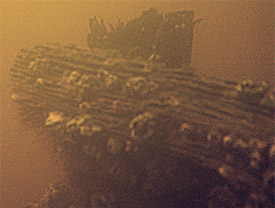
Portion of the centerboard of the "Padgett Vessel"
As Amy mentioned in Monday’s entry, we set up our control points, or datums around the vessel site – 8 in total. Metal fence posts served well, especially when sunk about half way into the bottom. To inhibit movement in these control points, two rebar stakes were inserted into the sand behind each control point forming a triangle. A bungee cord going from one rebar stake, around the control point, to the other rebar stake proved an effective method to secure the control point stakes.
Once the distances between every control point were known (control point 1 to 2, 1 to 5, 4 to 8, etc.), it was possible to construct a digital grid on a laptop. This alone forms a grid of known proportions in a dimensionless coordinate system. Tomorrow, most likely, we will be taking GPS positions of all eight control points so as to georectify the grid by UTM. Today, however, we decided to try out our grid and begin mapping prominent features of the vessel.
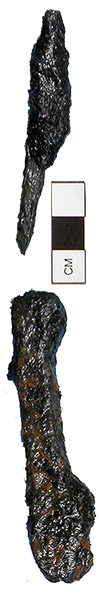
Sample fasteners recovered from dredging.
Site Recorder recommends that when recording the location of a position within the grid that the distance to that point be measured in relation to four control points. Ideally, these distances would form an “X” when converging on the point and, if the four points of that hypothetical X were connected themselves by lines, the resulting polygon would be similar to a square or rectangle. Measuring a point from four control points close together or only, say, on the port side of the point would introduce bias, essentially “pulling” the point towards those control points when the measured point was mapped on the laptop. In addition, tape measures originating from a control point extending to a point of interest cannot drape over scantlings of high relief. This causes a vertical error, yielding a distance measurement that is too large and incorrect.
With this in mind, we took the positions of four points that formed the extents of the centerboard trunk: forward port corner, forward starboard corner, aft port corner, and aft starboard corner. Each of these points required four separate measurements. Moving on, we fixed the position of the stem and stern post's as well as nine pilings that were driven through the starboard side of the hull at some point after abandonment. Whether these pilings were installed as a way to pin down the abandoned vessel, or if they are evidence of the ever-changing maritime cultural landscape, is unknown. What is known is that they are there and we must measure them.
Despite our attentions to this one particular method, this will not be our only method of recording the hull. While this work was done, dredging was coming closer to completion, preparing the vessel for hand mapping via horizontal offsets. We hope to preserve a mutualistic relationship between these two methods and to compare the results of each. Though I make no attempt to predict the politics of my comrades, we all seem to be conservatives on this point. After all, if it ain’t broke, don’t fix it. Perhaps not, but as humans always do, we will tinker in an attempt to make things better.
For more information you can visit the ECU website at:
http://www.ecu.edu/maritime/index.htm
Return to Project Journal home page.