One of the priorities of the site investigations throughout the years was the creation and enhancement of a comprehensive site map. Click here to view slide show (requires JavaScript)
Site Plans
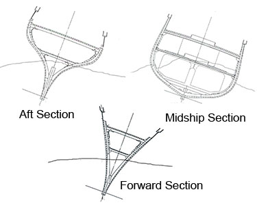
The results of sonar readings, ROV digital photography, and diver investigations in addition to historical documentation of the ship have aided in the construction of projected surviving hull structure drawings. Almost three meters of sediment made up of shell hash, sand, and pebbles has settled in and around the CSS Alabama. Very little of the hull structure is visible at the site, as high currents have eroded most of any exposed structural elements.

