The Lake Ontario Maritime Cultural
Landscape Project
24 July 2007
By Ben Ford
Lake Ontario is the smallest of the Great Lakes, but it is still a Great Lake, and with 1,168 kilometers (726 miles) of shoreline, surveying its entire edge would take a lifetime. While I enjoy school, I would someday like to rejoin the world of the working, so a sampling strategy was necessary. I decided to study the entire shoreline, but to especially focus my energies on eight one-kilometer (0.62-mile) square areas along the lake shore. Each area would be situated so that half was on land and half on water. Each area will be archaeologically surveyed (more on this in coming entries), and the surrounding region will be investigated through archives and interviews. The survey area-specific data and the regional information will then be integrated into data from the entire lake shore including historical context and known archaeological sites. Through this approach, I will hopefully be able to discuss Lake Ontario as a whole and still graduate before the professors start using me as a cautionary tale.

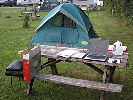
My “home office” during the summer of 2006.
But where to center the survey? To answer that question, I took a trip around the lake for seven weeks during the summer of 2006. I camped for the duration of the trip because I was constantly on the move and had a limited budget. I came to appreciate warm KOA showers and the Walmart tent that saw me moistly through a tornado. This trip had three principal goals: to conduct archival research, to make contacts in the local archaeology communities, and, lastly and most importantly, I wanted to ‘put an eyeball” on Lake Ontario (otherwise known as a reconnaissance survey). The first two goals met with resounding success. I visited 16 repositories, collected better than 100 pages of notes, and a substantial number of maps and images. I was also warmly received by both professional and avocational archaeologists, many of whom offered helpful suggestions and critiques.

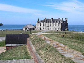
View of Fort Niagara from the gatehouse. (large view)
The third goal, of selecting areas to survey, however, got off to a rockier start. Much of the lake margin is heavily populated, especially the Golden Horseshoe from Niagara, past Hamilton, to Toronto. Along much of the rest of the lake, settlement is concentrated near the mouths of rivers that run out between high headlands. In these areas, modern towns have largely obliterated the earlier European, Canadian, American, and Native American/First Nations settlements. Portions of the lake shore also suffer from erosion, as much as 3.8 meters (12.5 ft) per year. None of this boded well for finding archaeological sites along the shore. However, as I drove east through Ontario, the population thinned and the topography changed. By the time I reached the Bay of Quinte, I was feeling much more encouraged. This portion of Ontario was first settled by the French in 1673 with the establishment of Fort Frontenac at the present site of Kingston and hosted early settlement by United Empire Loyalists following the American Revolution. Here, many of the old settlements are largely unchanged since the nineteenth century. On the other side of the St. Lawrence River, Jefferson County, New York appeared similarly attractive. Jefferson County was not substantially settled by Americans until the late eighteenth century, but it has a long history of Native American habitation. As a result of the underlying bedrock, Jefferson County also has more embayments and islands than much of Lake Ontario. These features help protect the shore and limit erosion, increasing the potential for extant archaeological sites along the water’s edge.
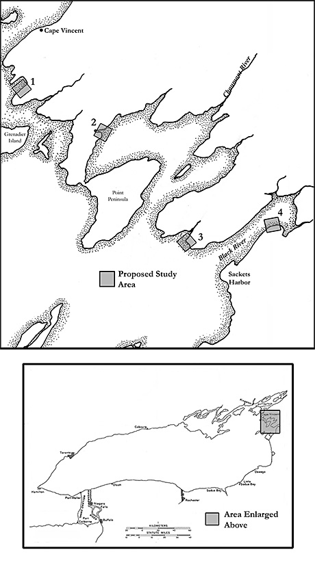
Having selected the general regions for the study, all that remained was to identify the specific survey areas. These areas were selected based on their level of 20th-century development, degree of modern shoreline modification, number and density of intact historic structures and landscapes, historic access to shore, presence of tributaries, and severity of shoreline erosion, as well as the presence of recorded archaeological sites, and the probability of unrecorded archaeological sites, as indicated by historic documents and maps. The map on this page shows the areas selected for Jefferson County. I have not yet picked locations along the Ontario shore and will not conduct fieldwork there until summer 2008. The methodology to investigate the survey areas will include an offshore side-scan sonar and magnetometer survey followed by diver inspections of targets, combined with diver surveys of areas too shallow to tow the equipment, informant interviews, and pedestrian surveys of the terrestrial portions of each survey area. Future journal entries will detail each of these aspects.

Jefferson County, New York survey areas. (large view)
Please feel free to contact Ben at ben.ford@iup.edu with any comments, questions, or suggestions during the weeks to come.
Return to Project Journal home page.

