The Lake Ontario Maritime Cultural
Landscape Project
19 March 2008
By Ben Ford
In this entry I’d like to focus on the preliminary results from the Long Carrying Place on Point Peninsula in the town of Lyme. This narrow bay takes its name from the portage route that began and ended here. From the end of the bay it was an approximately one mile trek across the isthmus to a stretch of beach sheltered by Fox and Grenadier islands where the boats could be put back into the water. There is some indication that Champlain was taken over this route during his tour of the lakes.
Eight archaeological sites were identified in this area, as well as one isolated find. The isolated find consisted of a 5.5-m long hardwood stick (possibly oak) that may have been lost from a raft originating at the Cherry Island lumbering operation. The archaeological sites in the area include the remains of a log cabin, three historic farmsteads, a blacksmith shop, at least two prehistoric sites, and a hay-dock with associated barn. There may be other sites situated in the inlet as we recorded several magnetometer hits in areas with deep muck. Unfortunately, none of these appeared to be the gold-filled cannon that lore has it was stashed somewhere in Long Carrying Place.
Map of Long Carrying Place with cabin and haydock sites indicated. Click on map to zoom in for a closer look.
One of the prehistoric sites is likely the Northrop Site described by Ritchie (1944:173) as a Point Peninsula Middle Woodland group burial. The other consisted of a collection that was centralized near the head of the inlet with artifact densities dropping off quickly on either side of the bay. Unfortunately, the collection has been lost so it is impossible to analyze the material. Given its location, however, it was likely associated with the portage. The log cabin may have also been associated with the portage; unfortunately it has also suffered in recent years. What remained of the cabin was burned during the 1990s and no artifacts were visible on the surface. The cabin site is situated on a point controlling access to the portage and with easy access to the water. It is also a substantial distance from the historic road, suggesting that it was intended to be approached by water rather than land.
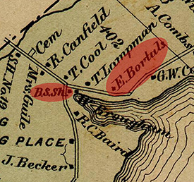
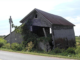
Two of the farmsteads, one standing, the other an archaeological site, are representative of the mid- to late-19th century farms that line the road along the peninsula. The third is potentially more interesting because it is in association with the blacksmith shop and haydock/barn. Much of this property is now owned by a single family, but historically, the haydock and the blacksmith shop were owned separately. The blacksmith shop was erected by Abner Rodgers as early as 1840 and certainly prior to 1864 when it appears on a map. Based on later description of the structure and its alterations it is likely the structure still standing (barely) near the head of the bay. Immediately east of the blacksmith shop was the smith’s house (Brougham on map) and another home, neither of which is still standing.

1864 map of Long Carrying Place with the blacksmith shop and Bartell (Bortals) residence highlighted.
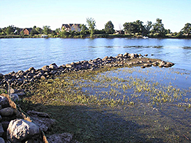
Slightly farther east is the standing Becker home, built in the mid-19th century and inhabited beginning in the 1860s by Fred Bartell (Bortals on map). Bartell was a cooper and boat builder, which was convenient because he also operated one of the two major haydocks on Point Peninsula. The cooper shop next to the house was torn down in 1953 but the haydock is still intact. The remains of a sweeping path approaches the haydock from the main road and passes the foundation of the barn. The barn was built in 1885 based on a carved stone salvaged from the foundation and presumably was used to store grain prior to being loaded onto the scows (flat sided vessels used to transport materials on protected waters). The dock took advantage of the protected nature of the inlet and the relatively deep water near its center to load grain grown on the peninsula onto scows for shipment to Oswego, Sackets Harbor, and Cape Vincent. Bartell seems to have taken advantage of the location of his home to expand his business from coopering to boatbuilding (if you can keep water in you can keep water out) and built many of the scows used in this trade, in addition to several fishing boats. The exact location of the boatbuilding operation is unknown but there is an area near the haydock that appears to have been graded to an average slope of 80 that is the most obvious spot for boatbuilding.

Blacksmith shop.
Thus, there was a small cluster of industrial activities: blacksmith, cooper, and boatbuilder, around the transportation node of the haydock. This cluster fulfilled many of the needs of the farmers strung along the peninsula between the towns of Three Mile Bay and Point Peninsula, and formed one of the primary links between the terrestrial agrarian system and the maritime transportation system. Transportation and industry were combined in this instance to form a kind of “one-stop shop” for local farmers.

Haydock remains.
It is also worth noting the coincidence of two different forms of transportation, historic and prehistoric, in this small bay. Native Americans and European Americans may have selected this spot for different reasons, but both groups likely benefited from the protection offered by the bay, although this may have been less of a concern for boats to be portaged with their paddlers. The visibility of the spot may have also been a consideration. The deep cut of the narrow bay with its high bluff to the east is easily identified from the water and may have made it a convenient location to begin a portage because it allowed each trek to begin from the same location reducing the chances of wandering off track. Similarly, the haydock may have been difficult to see but its geographic setting would have permitted boatmen to easily navigate to it. This overlapping of historic and prehistoric sites along the shore is not uncommon, as suggested by the prehistoric and historic sites at Storrs harbor, discussed in the last journal entry.
Please feel free to contact Ben at ben.ford@iup.edu with any comments, questions, or suggestions during the weeks to come.
Return to Project Journal home page.

