The Lake Ontario Maritime Cultural
Landscape Project
26 February 2008
By Ben Ford
It has been a long time since my last journal entry. I have no excuse other than that there are simply not enough hours in the day. However, I doubt this problem is confined to archaeologists or graduate students.
In return for your patience, I can offer preliminary results. Other projects and responsibilities took me away from this research for much of the autumn but I recently had an opportunity to return to the data, tally up the sites and isolated finds, and begin to look for patterns (after all, what is anthropology but the search for patterns in human behavior). And I’m glad to report that the results are promising. After a long season of survey I was a bit disappointed in the number of sites that we identified, but with a fresh perspective and a few months of separation, the results seem much more promising.

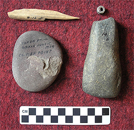
Artifacts recovered by amateur archaeologists from the Storrs Harbor area. Note the net weight in the lower left. (large view)
We identified 21 sites, the vast majority of which were not previously recorded. These sites ranged from the Middle Archaic Period (at least 5000 years ago) to the late 19th century and included habitation sites, a Spanish-American war firing range, hay docks, an ice house, and possibly a War of 1812 shipwreck. Even more exciting - some of these sites are forming patterns. For example, two of the survey areas included narrow bays (Storrs Harbor and Long Carrying Place) with Point Peninsula tradition (after circa 900 years ago) sites along their margins. The presence of these sites is interesting when compared with the broader, rock-bottom bays of the other two survey areas (Sherwin Bay and Wilson Bay) where no similar sites were identified. This dichotomy suggests that Native Americans of the Point Peninsula period were attracted to Storrs Harbor and Long Carrying Place. Dr. Timothy Abel has suggested that this attraction may have been the ability to seine for fish by stretching a net across the narrow bay. Artifact collections from both areas contain worked stones that appear to be net weights, supporting this hypothesis. Further analysis will hopefully shed more light on this pattern.
Another pattern at Storrs Harbor is the repeated interface between land and water in military service at the beginning and end of the 19th century. During the War of 1812, Storrs Harbor was used as a shipyard to construct the approximately 2800-ton Chippewa, sister ship to New Orleans that was built at Sackets Harbor. Chippewa was never launched, but the archaeological remains of the intensive effort to build her are still present. This site is being excavated by Dr. Timothy Abel and volunteers from the Jefferson County Historical Society. We can expect many interesting finds and excellent information in the future.

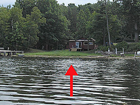
Storrs Harbor landing place with a later camp in the center (indicated by the arrow). Note the high ground to either side and the flat rock just visible at the waterline. (large view)
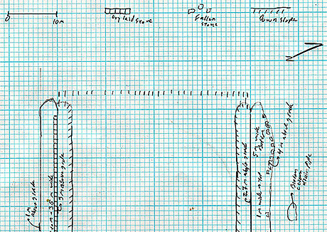
At the other end of the century, the Storrs Harbor area also includes Spanish-American War period training facilities associated with the nearby Madison Barracks. Situated on top of the hill is an earth and stone firing range measuring 48 X 66 meters with 5.5-meter walls. Very little is known about the range except that was likely in operation from Spanish-American War through World War I. Likely associated with the firing range is a graded landing place along the shore of the Black River just down the hill from the firing range. By some accounts this landing place was excavated around the turn of the 20th century by soldiers from Madison Barracks as a form of punishment and was used for landing barges and for bringing caissons onto Storrs Point over the ice. The landing place takes advantage of an exposed rock ledge to provide a smooth landing site and the excavated depression provides an easy grade from the waterline to the top of the terrace. According to informants, soldiers and cannons were regularly sent to Storrs Point by barge or over winter ice and then made to march the 2.5 miles back to the barracks. It is likely that these soldiers used the firing range on the hill to practice their marksmanship. Other elderly informants reported recovering large amounts of lead shot from two areas of the shore immediately west of the survey area. During the winter when the river was frozen, soldiers would fire from the ice using the high bluffs in these areas as backstops. It seems that much of Storrs Harbor was converted to first a shipyard and later a training ground as the need arrived. As the analysis progresses it will be interesting to see if this is a coincidence or related to some identifiable pattern of use.

A portion of the field map of the Storrs Harbor firing range. (large view)
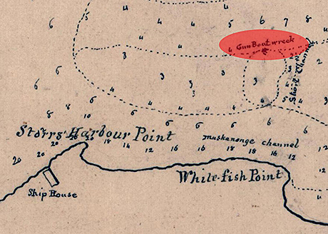
Also exciting is the possibility that we’ve located a War of 1812 gunboat. Near the end of the war, the Americans were trying to put as many guns on the water as possible and were also preparing for a possible amphibious attack on Canada. Gunboats figured in both strategies and 15 of these open boats were at built at Sackets Harbor in 1814. It is likely that they were built following the plans for a 75-foot gunboat used in other areas, such as Lake Champlain and the Chesapeake Bay, and would have had a cannon at each end. However, the war ended before the boats were outfitted and they were tied up at Storrs Harbor. Not long afterwards, one of the gunboats broke its mooring in a storm and drifted out into the Black River before it grounded on a sandbar. It is uncertain why the boat was not salvaged, possibly because it broke its keel on the sandbar, but an 1829 chart shows the gunboat wreck near the project area. After “rubbersheeting” this historic chart to correspond to the modern landscape and comparing the location of the gunboat to several magnetic anomalies recorded by the magnetometer, I am 70% confident that we have located the gunboat. Unfortunately, this area is still a sandbar and there is no surface evidence of the vessel. Future work will involve probing in the area to determine if there is anything solid beneath the sand and possibly excavating test trenches to investigate the condition of the wreck. An excavation here may be worthwhile because these gunboats were an early attempt by the US Navy to design a vessel at the Washington Navy yard and have identical boats built in different locations. However, we know from two other archaeological examples that these plans were adapted to the economic and environmental conditions of where they were built. The question is, how was the Lake Ontario gunboat built and how does it compare to the official plans and other archaeological examples.
Good stuff. And there is more to come. As I prepare for the upcoming field season (May–July this year) I’ll report back with more findings from last year and a progress report on the preparations for this year. As always, if you have any questions or comments, please email me: ben.ford@iup.edu.

Portion of the 1829 Sketch (a vue) of the Mouth of the Black River and Waters Adjacent (National Archives RG77 Civil Works Map File D77; courtesy of Gary Gibson). (large view)
Return to Project Journal home page.

