
- MUA Home
- All Project Journals
-
- Introduction
- 4-7 Feb 2008
- 9 Feb 2008
- 10 Feb 2008
- 11 Feb 2008
- 15 Feb 2008
- 24 Feb 2008
-
- Crew Page
- Flinders 2008 Field School Information
- Maritime Archaeology Postgraduate Programs
- Flinders Newsletter
- Flinders U. Program
-
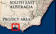
- The top banner of this page is made from two maps drawn and engraved By J. Rapkin, H. Warren, J. Rogers, J. & F. Tallis. The maritime scene depicts Melbourne, Australia on Port Phillip Bay. This year's field school takes place across the bay near the town of Portarlington. The maps were published in The Illustrated Atlas, And Modern History Of The World Geographical, Political, Commercial & Statistical, Edited By R. Montgomery Martin, Esq in 1851. Both maps are provided courtesy The David Rumsey Map Collection.

Flinders University 2008 Field School
in Underwater Archaeology
4 - 7 February 2008
By Peter Ross
February 4, 2008 - In Transit
We arrived in sunny Portarlington after a long, hot journey from Adelaide and set up house in the caravan park. That night field school director Mark Staniforth assigned duties to the various teams for the next day’s diving.
February 5, 2008 - Clifton Springs Long Jetty
Today the Green Team (me, Nicole, Anthony, and John) took two boats with Aggie and Hannah as boat handlers, and Sam and Jun as supervisors. We did a snorkel reconnaissance of the far end of the jetty to determine its structure. We discovered that the head of the jetty did not have either a U-shaped or an L-shaped structure (no evidence of piles or other structural construction), but rather appeared to be unchanged from the rest of the jetty.
We then laid out the planned excavation area. This area is 3m x 40m and extends from the immediate south-east side of the jetty, crossing under the jetty to the north-east side and extending a further 36m to the north-east at a right angle to the jetty. This section was marked using 2cm x 2m plastic rods hammered into the sediment. No excavation was conducted during this procedure.
Heavy beams and cross-members, likely the jetty’s flooring reinforcement, mark the area close to the excavation area nearest the jetty, and further out towards the head of the jetty. They vary in size from 1m long reinforcing timber remnants (many with iron fastenings) to 3m x 5m sections of flooring reinforcement. Most of this remnants and jetty piles are covered with a filamentous green algae, obscuring detailed observation. The entire area surrounding the jetty is fine sand and crushed shell sediment with evidence of a very large population of bi-valves.
This night we had a presentation by Sam Turner from the Lighthouse Archaeology Maritime Program who informed us about the wooden ship building program in Florida.
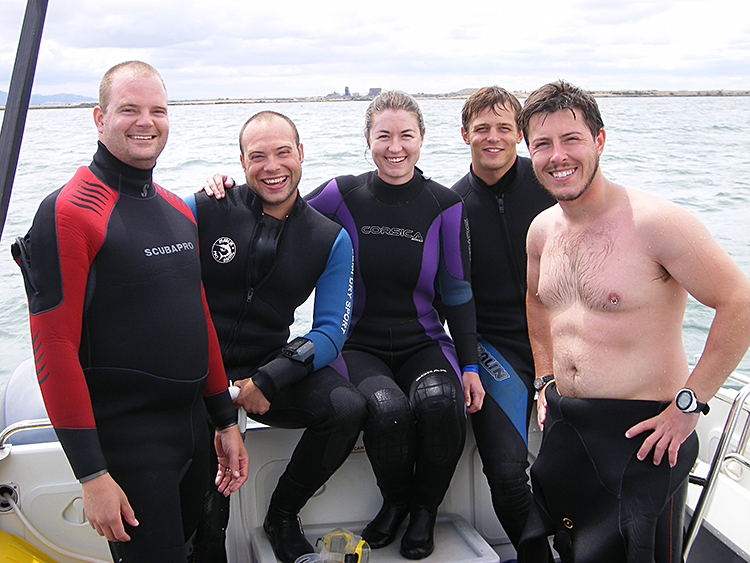
Figure 4- White team: Kenny, Ben, Matt H and Darren ready to dive on Aniuera (Large View).(photo courtesy of the Maritime Archaeology Program, Flinders University)
February 6, 2008 - Aniuera
The Green team was split in half today. Nicole and John left for magnetometer training while Anthony and I went to the Aniuer, a 1350 ton wooden ship scuttled. After consulting with the onsite team, we agreed to plot the area from the bow to the anchor. We tied the measuring tape, that marked our baseline to the anchor, at the point of the anchor where the shank met the stock. We then extended the baseline and tied it to a wooden stake that the onsite team had installed near the bow. The baseline measured 37.5m. After this we began plotting artifacts using the baseline/offset method. We used this method because it suited the relatively flat aspect of the wreck, and because measurements could be taken quickly and accurately.
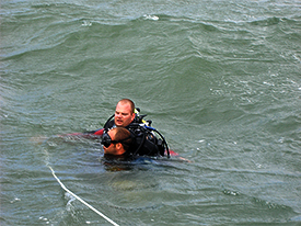
Figure 5- Kenny and Ben in rough seas on Anieura (photo courtesy of the Maritime Archaeology Program, Flinders University)
This night we had a presentation by Andy Dodd who informed us about historical shipwreck conservation and ongoing cultural heritage management of maritime affairs in New Zealand.
February 7, 2008 - Clifton Springs Long Jetty
Today John decided that field school was not his cup of tea, so he withdrew and now we have an odd numbered team. Luckily, our friendly and competent supervisors have volunteered to be the dumb end (the person holding the zero end of the tape measure) on our team’s projects.
We installed a baseline with the zero point on the most northerly remaining pile that is visible above water. This pile is on the eastern side of the jetty. The baseline was then tied to a submerged pile some 50 meters south, also on the eastern side of the jetty. One buddy team (me and Anthony) then recorded the remaining piles on the western side of the jetty, while the second buddy team (Nicole and Jun) did the same on the eastern side of the jetty.
This night we had a presentation by Jason Raupp who informed us about historical shipwreck conservation and ongoing cultural heritage management of maritime affairs in Florida, as well as that State's controversial treasure-hunting permit process.
Comments, questions, or suggestions?
For field school related issues please contact: mark.staniforth@flinders.edu.au
For website related issues please contact:
mua@keimaps.com
Return to Project Journal home page.