in Underwater Archaeology
By Larry Babits, David Stewart, and
Jeremy Eamick
Project Introduction
The East Carolina University’s Summer 2007 field school will encompass three different sites in the rivers of North Carolina, allowing the students to experience a wide variety of archaeological recording techniques. Our first task will be a return to the Washington Park Vessel, the primary focus of our Fall 2006 fieldwork. During that time we dredged out the vessel, made a complete site plan, and recorded a number of artifacts (mostly fairly modern trash). Research over the past several months has increased our knowledge of the vessel, but some questions can only be answered by returning to the site to record additional data. Specifically, we need a better understanding of the curvature of the hull in order to draft an accurate set of lines drawings. Instead of using a traditional offset method to measure several cross-sections, we will be using a device called a “goniometer” for faster and more accurate recording (Cozzi 1998).
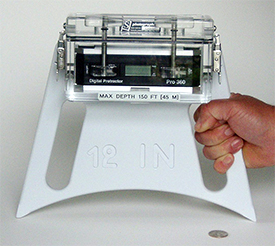
The goniometer is nothing more than a level mounted on a base of known length. To use it, the archaeologist starts at the vessel’s centerline, places the goniometer at the seam where a frame meets the hull planking, and notes the angle. Recording proceeds outward along this same line, with the diver noting the angle at each segment. Back in the lab, the angles and distances can be plotted on paper, rendering an accurate drawing of the shape of the hull. Fortunately, a budget increase provided us the funds to purchase two complete sets of digital goniometers, which were custom made for us by Sexton Photographics of Salem, Oregon (www.thesextonco.com) (Figure 1). The next step is to see how they work on site, and if they will give us the information we need to reconstruct the shape of the Washington Park vessel’s hull.

Figure 1: Goniometer used to record hull curvature. Photo by Ken Sexton.
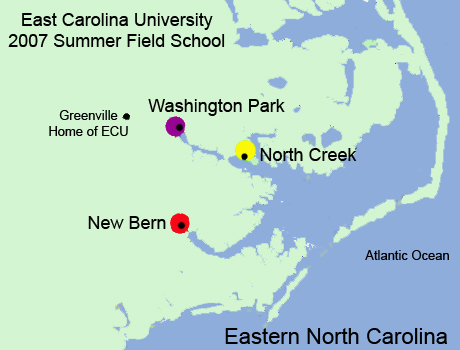
After completing our work on the Washington Park vessel, we will move to North Creek, a tributary stream entering the Pamlico River about halfway between Bath and the Pungo River. ECU first surveyed this “Y” shaped embayment in 1994, and we have been back several times since then. The first survey indicated the remains of over 40 vessels, as well as numerous magnetic anomalies that had not yet been ground truthed. In the last five years, heavy development has begun and roads now extend to the water in previously uninhabited areas. This development includes small marinas and docking facilities, as well as efforts to remove obstructions. Chief among these obstructions are abandoned watercraft, some of which have been pulled out of the water and burned; others have simply been burned to the waterline.

Eastern North Carolina and the 2007 ECU Fall field school site locations.
This rapid alteration of the archaeological record is part of a traditional recycling of watercraft in the Pamlico Sound area. Our intent is simply to record what is there before it is altered. To that end, the field school will conduct survey and recording operations in three areas. First, we will record through traditional hand mapping the well preserved remains of a vessel with the intriguing nickname of the “Kickin’ Bitch”, a locally built one mast bateau. In conjunction with this effort, we also plan to examine two boat graveyards. One is associated with a marine railway in North Creek’s west prong; the other is immediately north of Credle Point. The Marine Railway complex has at least ten vessels fully submerged or awash that date from circa 1890 to 1960. We will attempt to minimally record all the vessels and the railway. Across the west prong is Credle Point, a longtime shipbuilding site and also the residence of the Credle family since 1770. Around the point are several sunken vessels and, on the north side is a cove that is probably full of silted over vessels. This area will be subjected to remote sensing with some limited ground truthing.
Time permitting; we will also survey the west prong of North Creek approximately one mile further inland to relocate targets found in 1994. Some of these targets were identified by name by Glen Credle, a local resident who has provided a great deal of information about this area. Glen is providing us with docking facilities and land space to store our gear while we are working on North Creek.
The final week of the field school will be devoted to a remote sensing survey off shore of New Bern. Students will use side scan sonar and magnetometer equipment to search for undisclosed shipwrecks around Union Point. New Bern has long been a center of maritime commerce. This phase of the field school will gather data for use in a thesis project for Jeremy Eamick, one of the field school participants, focusing on how the maritime trade has affected New Bern’s cultural landscape. Like North Creek, development around Union Point has threatened the cultural heritage hidden under the waters. This survey will hopefully reveal evidence of shipwrecks that may become the focus of further study, as well as enhance understanding of the waterfront’s changes through time. New Bern’s tercentennial is in 2010, and the information from this survey and Jeremy’s thesis will be incorporated into those celebrations.
This year’s Summer Field School participants will have a wide range of archaeological opportunities: hands-on experience with goniometers, side scan sonar, and magnetometers; ground-truthing sites potentially dating back to the 18th century; hand mapping a small vessel in muddy river water. We look forward to the opportunity to present these experiences through this field journal.
Information sourced from:
Cozzi, Joseph.
1998 The Goniometer: an improved device for recording submerged shipwreck timbers. International Journal of Nautical Archaeology 27.1: 64-80.
Please feel free to contact us at mua@keimaps.com with any comments, questions, or suggestions during the weeks to come.
Return to Project Journal home page.

