


On December 20, 1606, three ships, the Susan Constant, the Discovery, and the Godspeed, set sail from London, England, for the New World. The voyage was launched by the Virginia Company of London under a charter established by the English Crown as a largely commercial enterprise. Five months later, on May 13, 1607, the colonists disembarked on Jamestown Island, Virginia, and established the first permanent English settlement in the New World. This year, Jamestown Island observes the four hundredth anniversary of the founding of “James Cittie.”

Onboard Big Blue. The research vessel is equipped with four monitors to look at the side-scan sonar and navigation data. (Photo by Steve Brock)
Throughout July 2006 underwater archaeologists Steve Bilicki, principal investigator BRS Research and Survey, and Jodi Carpenter, MA candidate East Carolina University, designed and conducted a Phase I pre-disturbance side-scan sonar survey around Jamestown Island’s waterways. This project was accomplished in conjunction with the National Park Service and Colonial National Historical Park archaeologist Andrew Veech. Undergraduate Steve Brock, Indiana University of Pennsylvania, rounded out the four-person survey team. This survey was the first comprehensive underwater survey of Jamestown Island encompassing the island’s entire 7.8-mile shoreline.

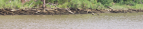
Ground-truthing confirmed the existence of seven flat-bottomed wooden barges at this site. They are clearly visible on the shoreline as well as on the side-scan sonar. (Side-scan image-Oceanic Imaging Consultants, Honolulu, HI)
The survey began on July 5, 2006, and ran for ten days. Field work was conducted off the twenty-five foot Parker research vessel Big Blue owned by GEOMAR, LLC. The survey encompassed Jamestown Island’s entire 7.8 mile shoreline and the results were promising. Through a visual search of the shoreline, side-scan sonar, and follow-up research trips, the survey yielded potentially over 60 sites.
View of the multi-barge site as seen from the water. (Photo by Steve Brock)
The bulk of the survey’s findings were the existence of 25 shipwrecks. Ironically, as Jamestown Island became a National Historical Park, its waterways became a dumping ground for twentieth century barges. The survey confirmed ten barges in the Back River, four barges in the Thorofare, three to the south of the island and one off the western shoreline. Local historian and former Jamestown Island resident Rodney Taylor shared pertinent oral history about the abandoned barges. According to Mr. Taylor, many of the barges were abandonment’s of companies that operated out of the Back River. One company, the Tennis Sand and Gravel Company, operated when Mr. Taylor lived on the island as a boy in the 1930s. The survey team located the remnants of a brick landing owned by the company eroding into the Back River.

Two of the Thorofare barges are visible above the surface, one of which contains machinery parts.
Jim Bozarth, another lifetime area resident of the area, discussed the Thorofare barges. The Bozarth family operated lumber businesses around the turn of the twentieth century in the Williamsburg area. Mr. Bozarth recalled that his grandfather and two great uncles intentionally sank some derelict barges in the Thorofare. The massive size and sturdy construction of many of the barges located during the survey suggest that these vessels may in fact be the former lumber company’s abandonments. Mr. Bozarth also recalled that the lumber company once owned a two-masted centerboard schooner called the Widgeon. Interestingly, the survey team did locate a centerboard schooner in the Thorofare, misidentified as pilings on existing navigation charts. Unfortunately, Mr. Bozarth was not familiar with the fate of the Widgeon. Whether or not this centerboard is actually the Bozarth’s Widgeon presently remains a mystery. Court records have confirmed the existence of both companies and their location in the Jamestown and Williamsburg area.
Several other wrecks were located off Jamestown Island including two 40-foot wooden wrecks. Other survey findings included a prehistoric shell midden eroding into the Back River, a multi-component landing site at the former bridge, and a probable seventeenth century landing.
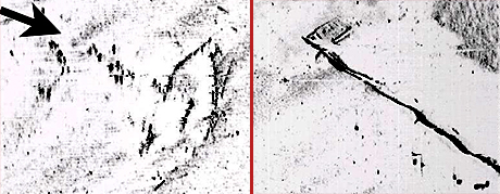
The centerboard schooner (left image) and barge (right image) are marked as pilings on the navigation charts and do have pilings associated with them. The barge is an estimated 90 feet by 30 feet. (Side-scan image-Oceanic Imaging Consultants, Honolulu, HI)
Many other anomalies still need to be ground-truthed, but the preliminary results of the 2006 underwater survey hold promise. Overall, the journey around Jamestown Islands waterways proved that the islands history did not begin or end with arrival of the 17th century English colonists. Many submerged remnants of human activity pre- and post-dating James Cittie await further study and interpretation.
Comments, suggestions, or questions can be directed to jodileecarpenter@yahoo.com
Return to In The Field home page.