


Institute of Maritime History:
New Castle Delaware Project
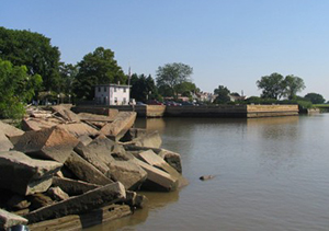
New Castle Harbor with a crumbling ice pier on the left and the old ferry dock in the background.
During the week of 16-22 July 2006, volunteers from the Institute of Maritime History investigated the historic harbor area at New Castle, under the guidance of Mr. Craig Lukezic of the Delaware Division of Historical and Cultural Affairs. The goal was to locate and map material remains of maritime activities.
Founded in 1651 as a Dutch fort on the western side of the Delaware River, New Castle was the first source of fresh water for vessels entering the river in colonial days, and became the first capital of Delaware. It passed to English control in the third Anglo-Dutch War, 1684, and remained an active seaport for exactly three centuries. Linked to the Chesapeake Bay by road and later by railroad, New Castle served as a major point for transshipment of cargo and passengers moving along the eastern seaboard. Its last commercial navigation ended in 1951 when the Delaware Memorial Bridge opened and the ferry service to Penn's Landing, New Jersey, shut down.
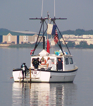
Divers return to boat after investigating a sonar target.
The search area covered the New Castle waterfront area and extended to the edge of the shipping channel. A total of 26 volunteers participated in the harbor survey, probing the shoreline area and using sidescan sonar to investigate the deeper river waters.
Most of the harbor is filled in or heavily silted over. Sediment depths are more than 8 feet in places. The silt was not removed or disturbed. Many small artifacts were found along the waterfront. However, they were broken and anachronistically mingled, and appear to be landfill. Findings ranged from ceramics to roof slate, brick, and glass. As this was a Phase I examination, artifacts were photographed and replaced in their original locations.
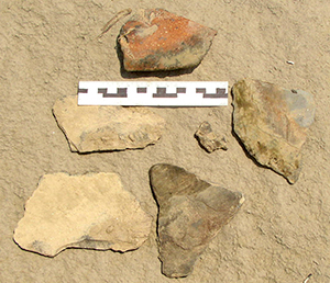
Roof slate and ceramics discovered in shoreline fill
Two large structures offshore were found by sidescan sonar. One is the remains of the diamond shaped "ice pier" (shown above) that was destroyed in 1927. The sunken ice pier lies northeast of the extant piers. Seven surviving ice piers, dating from 1803 to 1880, are listed on the National Register of Historic Places (number 1982-02-04).The other major structure appears to be the base of a coal pier, measuring approximately 75 by 120 feet. The colonial harbor lay inside two 1803 piers but has since been filled in.
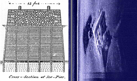
This drawing (above left) shows the basic construction of an ice pier. A wooden crib is filled with stone and faced with cut rock. The side scan image (above right) shows the remains of a diamond shaped ice pier that was destroyed in 1927. Divers located its remains and confirmed the presence of timbers and stone.
The IMH will submit a detailed report to the Delaware Division of Historical and Cultural Affairs.
For more information you can visit the IMH website at:
http://www.maritimehistory.org
The MUA would like to thank Steve Smith for contributing his images and Jim Meeks for providing the 1879 ice pier detail image used in this feature. For more information on New Castle, Delaware history visit http://jlmeek.com/chap/
I.M.H., Box 29, Kensington, MD 20895
301-949-7545
email: David.Howe@MaritimeHistory.org
Return to In The Field home page.