

- MUA Home
- All Project Journals
-
- Introduction
- Rebreathers
- Walter B. Allen
- Final Moments
-
- Introduction
- A Fair Wind
- Going Home
-
- Historical Society
- Shipwrecks
- Maritime Trails
-
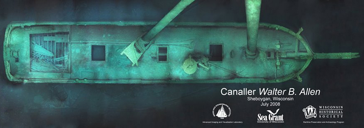
- The top banner shows the Walter B. Allen's bow taken at an approximate depth of 175 feet.

Project Introduction
25 August 2010
By Matt Carter

A view of a diver at a decompression stop taken from below. (photograph courtesy of Tamara Thomsen).
On the 19th of June I flew the 8000 miles from Christchurch, New Zealand, to Madison, Wisconsin, USA, to begin my summer internship with the Wisconsin Historical Society, Maritime Preservation and Archaeology Program. My role was to shadow and assist Keith Meverden, the State Underwater Archaeologist, with the various projects that were planned for the summer. This all changed when Keith as part of his Coast Guard reserve officer duties was deployed to New Orleans, Louisiana, to help with oil spill recovery, and I found myself in the position as principal investigator for the summer’s projects.
So here we go. Our first project is the documentation of the 136 ft two-masted canaller Walter B. Allen which sank in 1880 and now sits upright, intact, in 175ft on the bottom of Lake Michigan. The fresh cold water and depth has meant that the Walter B. Allen is amazingly preserved and as such, is well suited to provide us with information about this distinct vessel type which is unique to the Great Lakes. Another unique aspect of this project is that all divers will be using closed circuit rebreathers and tri-mix to allow for substantial bottom times and accurate recording at such depth. Outside of myself there are 8 volunteers that are assisting with collection of data and boat handling. Managing diver assignments and teaching ship construction terminology to the volunteers has also befallen me. More on this challenge later….

The Walter B. Allen Project crew (photograph courtesy of Tamara Thomsen).
In 2008, Woods Hole Oceanographic Institution - Advanced Imaging and Visualisation Laboratory created a high resolution photo mosaic of the Walter B. Allen. We are using that mosaic as a guide to assist in planning assignments and measurements to be taken underwater. The mosaic was created when their custom made 3D-HD video camera was mounted on the nose cone of a Silent Submersion UV-26 DPV. The camera was mounted in a downward facing position and the scooter and lighting array was piloted back and forth over the wreck with overlapping passes like that of mowing a lawn. Images from the video passes were merged creating the photo mosaic. The full resolution version of the mosaic allows so detailed of a view that you can count the invasive zebra mussels that populate the deck! It is hoped that the technology that is being designed and tested by WHOI will eventually create images with no greater than a 1 cm error.

A photomosaic image of the canaller Walter B. Allen (Large View). Image courtesy of Wisconsin Historical Society.
Ultimately the data that is collected from the survey will be used to nominate the Walter B. Allen for listing on the National Register of Historic Places. Right now, the State of Wisconsin has more shipwrecks listed on the National Register of Historic Places than any other state - a real tribute to the preservation ethic that exists within the state.
Return to MUA Project Journals home page.