
 [an error occurred while processing this directive]

East Carolina University 2007 Field School
in Underwater Archaeology
6 June 2007
By Melissa Ashmore
Today we were once again on the magnificent Kickin’ Bitch site. We have only two more days on the site, so we had to kick it in gear to get everything done. In order to do this, we once again split our efforts with Michelle, Calvin, and Dave spending the first half of the day running sidescan sonar, while the rest of us continued to map our sections of the ship.

The ECU dive barge.
Nadine and I ended up running the dredges for most of the morning because some of our areas had filled back in overnight. Also, as Jeremy wrote yesterday, I ran into some problems when trying to map the bow section, and we determined that I needed to dredge out some more of the area before I could record the details needed. Nadine was working in the stern, while I worked in the bow. After completing the dredging I continued to map my site, concentrating on small details in the bow. The bow itself is still in one piece and is very sturdy. All of the outer hull planks are still present and in their original position. However, very few of the seams between the planks in the bow can be felt. This is due largely to the fact that the wood is very grainy, and it is extremely difficult to distinguish between the grain and seams where the planks meet. Besides this problem, the front end of the bow is covered in tarpaper, which is exceedingly difficult to get off. There is also a section that is coated in what feels like a type of concrete; it fills all the gaps and covers a couple of the planks, making recording the details of this area difficult.

Dr. Larry Babits dredging out the bow.
In the afternoon, Larry dredged in both the stern section and in the bow. In the stern, he dredged down to the keel and then relinquished the dredge to Nadine to have her finish it. In the bow, he also dredged down to the keel. His reason for doing this was to allow both of these areas to be drawn in profile. While I continued to work on the details in the bow, Jeremy, who had finished his section, started the profile of the stem post assembly. Nadine has started the profile in the stern and will finish it tomorrow.

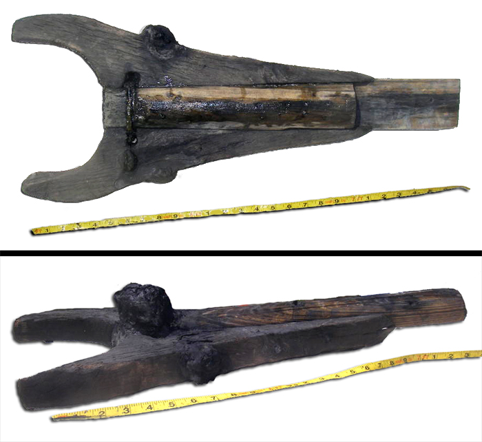
Plan and perspective views of the clamp end of the boom. (large view)
We have found a few interesting objects in the process of mapping. In Nadine’s section we found an 18 foot pole, which tapers at one end. This could either be the mast of the ship…or a tree. We don’t really know which, but we’re leaning towards tree. In my section we found a Y shaped artifact, that we are pretty sure is the clamp end of the boom. The boom is the piece that holds the bottom of the sail. The Y piece fits onto the mast and is then tied to it. After mapping it in relation to the baseline, we raised it and took pictures with a scale and then drew it to scale. After drawing it we replaced it on the wreck. We have also found several stringers, which are extra keelsons that run the length of the vessel. They are used to give extra support to the internal structure of the vessel (Editor’s note: See yesterday’s video here).

The students gather for an evening lesson in mapping their work.
After we left the site, we were given a couple hours to clean up and eat dinner, and then it was back to Eller House (our base of operation on the ECU campus) to work on our site map. We spent about an hour just reconciling our individual sections in order to put them together to form one large site map. There were several sections that have to be re-measured because they just did not match up. The reason for this is that the farther you get from the baseline, the less accurate your measurements are. Most of the information within six feet of the baseline matched up very well, or could be reconciled very easily. Tomorrow we will be re-measuring in order to fix this, and then tomorrow night we will finish our site drawing and get ready to ink up some mylar. Mylar is the plastic film that we use to draw on in the water, and we also use it to make the final site plan. It is durable, flexible, and lasts a long time in storage.
The last two days…and counting…on the Kickin’ Bitch. I think I may actually miss the mud. Okay, that was a complete lie, but next week we will be in New Bern. A new site and a new experience. Can’t wait.
Please feel free to contact us at mua@keimaps.com with any comments, questions, or suggestions during the weeks to come.
Return to Project Journal home page.