
- MUA Home
- All Project Journals
- Introduction
-
- Comming Soon!
-
- Crew Page
- Road Harbor Handbook 09
- Acknowledgments
- University of Bristol
-
- The image in the banner was photographed on the North site. It is a northward view of the contiguous section of sacrificial planks.

Introduction
19 May 2009
By Kimberly Monk
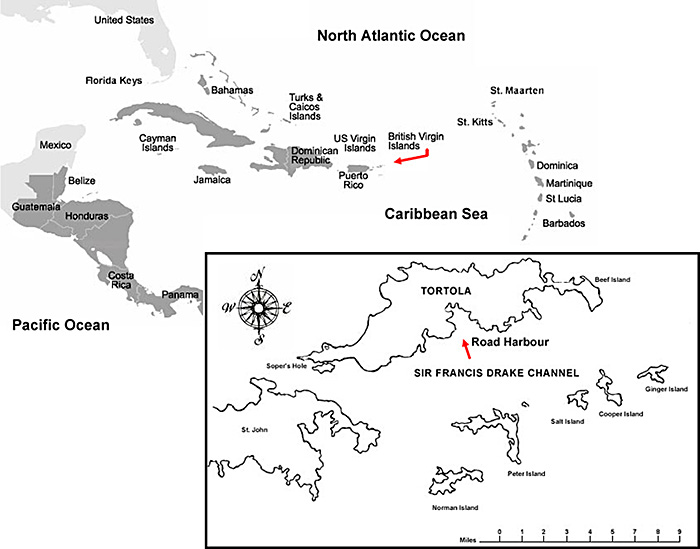
Since first sighted by Christopher Columbus in 1493, the Virgin Islands have been a refuge for naval ships and merchant shipping. Deep passages such as Sir Francis Drake's Channel (Figure 1) served as motorways for ships passing through the islands. Ultimately these ships needed to "refuel", or in historic terms, obtain fresh water, ship stores, and find shelter for protection from weather or enemy ships. Many of these natural harbours became safe havens for European vessels, and would develop into ports and marine fortifications. Interestingly, this so-called safe haven has revealed dozens of shipwrecks, offering a unique opportunity for archaeological study.

Figure 1: British Virgin Islands (inset: Road Harbour). Large View
Archaeological investigations of Road Harbour began in June 2005, in an effort to locate and document the remains of HMS Nymph, a 300-ton sloop of war that burned in Road Harbour in 1783. The site, reported following an encounter with a 1969 dredging operation was, however, not located. Instead, two separate and distinct shipwreck sites were identified and examined. These sites have provided an excellent research opportunity as well as an ideal location for training maritime archaeologists.

Figure 2: South Site Structural Complex.
Our work, to date, has focused on the South site, a circa late 18th/early 19th Century vessel of 60 tons, built for trade, and originating in Bermuda or Circum-Caribbean region. During the course of investigations, the team exposed a large section of articulated hull structure, amongst which ceramics and glass, weaponry, as well as a silver coin (dating to 1755) were located. The study of this site, completed in 2008, adds a new dimension to the characterization of pan Caribbean trade in an era of social, political and economic unrest.

Figure 3: Planned study area 2009 in red. Photo courtesy M. Kent.)
This year, we will be focusing on the North site (Figure 3), located approximately 50 feet north of the South site. Scantling (dimensions of ship's timbers) and wood typology suggest a vessel of approximately 250 tons, also built for trade, and constructed along the eastern North American seaboard (Table 1). The site, which was damaged as a result of commercial dredging activities in the 1960s and 1970s, poses challenges for recording activity. This is due to exposure of the wood (resulting in teredo navalis a worm which has consumed sections of timber) and material erosion out of the cut slope (thereby losing its context). Preliminary surveys have located a contiguous section of planks and a couple larger buried timbers, amongst which ceramics, glass, a section of copper sheathing, and various iron concretions have also been located.
Although our main objective will be continued survey of the North site (Figure 5), we will also be extending the survey area to inventory other submerged sites and objects in Road Harbour. With knowledge of these targets, we will be able to build a catalogue of these cultural resources thereby preserving data in advance of further changes to the harbour seabed due to dredging and land reclamation activities.
Our research goals for the North site are as follows:
- Continue investigating the site for additional structural components, focusing along the dredged channel, and with the intention to locate articulated structure.
- Locate ballast pile. We expect to locate a larger volume of ballast than at South Site due to correspondingly larger size of scantling.
- Continue wood sampling.
| North Site | ||
| Sample 10 | Sacrificial Plank | American White Pine |
| Sample 11 | Bottom Plank | American White Pine |
| Sample 12 | Frame | Red or Live Oak |
| Sample 13 | Trunnel | White Oak |
Table 1: Wood Samples from North and South Site (2005). Credit: Dr. Lee Newsom.
Finally, other sites and areas:
- Examine in further detail ballast and steel wreck sites, located by the ferry dock.
- Take closer look at other sites pointed out by Mr. Christopher Juredin (Commercial Dive Services) particularly those with structure, to establish size and to see whether they might be associated with either the North or South site (Figure 4).

Figure 4: Archaeologist examines articulate structure on the South site. Photo courtesy A. Jenik.
In sum, our investigations will continue to examine the importance of Road Town's maritime past. As a centre of cotton, sugar and indigo production, it became a bustling port for export to England and the American Colonies, during the eighteenth century. Furthermore, timber, salt and fresh water, were critical to local growth and to ships requiring supplies. With this increase in shipping, there were inevitably shipwrecks whose hulls were accidentally lost or purposefully abandoned. Our planned 2009 study will therefore present further opportunity to study these sites, through documentation of their physical remains.

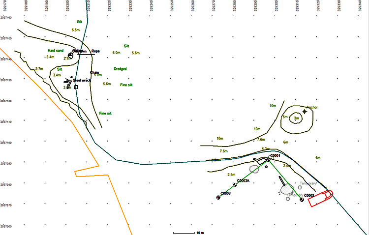
Figure 5: GIS Plan of North (C0001), South (C0002), Ballast and Steel wreck site in relation to western harbour breakwater (yellow) (2005). Credit: P. Holt. Large View
Please feel free to contact us at K.Monk@bristol.ac.uk with any comments, questions, or suggestions during the weeks to come.
Return to Project Journal home page.