

- MUA Home
- All Project Journals
- Introduction
-
- 22 May 2007
- 24 May 2007
- 28 May 2007
- 29 May 2007
- 31 May 2007
- 4 June 2007
- 5 June 2007
- 6 June 2007
- 8 June 2007
- 11 June 2007
- 12 June 2007
- 15 June 2007
- 20 June 2007
-
- Crew Page
- 2006 Field School
-
- The top banner of this page is a photograph of an oyster schooner docked at a cannery in Washington, NC circa 1890.

East Carolina University 2007 Field School
in Underwater Archaeology
11 June 2007
By Jeremy Eamick
The greatest days of summer school have begun. I have waited in anticipation for the New Bern portion of field school since this is what my thesis will be about. I won’t bore you with specifics about my thesis but I will provide details as to why we are stationed here. The New Bern portion of the field school includes the remote sensing survey of Union Point, that jutting earthen corner where the Neuse and Trent Rivers unite. The survey will use side scan sonar and a magnetometer to search the surrounding river bed for cultural features. This information will be included in a GIS database by the end of the summer. This database will be part of my master’s thesis, which will hopefully be finished next summer.

Union Point as seen from the Trent River.
My personal interest in New Bern was economics. I strongly believe that the most basic and helpful form of historical study is best done through economics. The continuation of modern society is based on money and profit, so the inventions and practices of trade are essentially done for profit. Historically, boats exist primarily either for profit, or the protection of these profitable boats. Dr. Bradley Rodgers once said that the best means of studying the “why” was through the economics. Dr. Rodgers is a smart man; we were at the time discussing the use of wooden ships in the Great Lakes while iron ships had already prospered elsewhere.
New Bern is one of those interesting places where the economic systems of eastern North Carolina came together. In the 1720's England transferred the colonial court system to New Bern. In 1746 the colonial government of North Carolina was seated in New Bern. The booming naval stores trade incited tremendous growth in the town, creating a colonial stopping point for shipping along the Atlantic coast. New Bern became a central export location in the 1750's and passed Bath and Beaufort as the leading trading port in eastern North Carolina.

The boats sitting at the quay, waiting for deployment. (large view)
The history of New Bern included the local maritime trade that was produced from the adjoining water connections to the interior Carolina cities. New Bern profited from this access and this attracted merchants to the city. This city became a central place, or, as the central place theory by Walter Christaller suggests, a place surrounded by secondary satellite locations that support the central place economically or structurally. This created a unique and beautiful town that prospered from the mid seventeenth century to the early twentieth century. My brief studies into New Bern’s history have excited my imagination and hopefully will help me learn as I strive for a master’s degree from ECU.
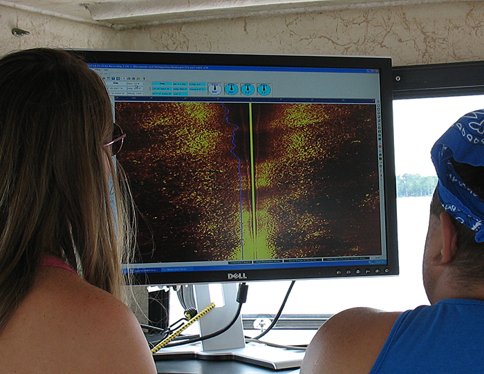
Today was the first day of work at New Bern. The team arrived last night and put the boats in the water to allow an early start this morning. We stayed at a local hotel thanks to the assistance of the Swiss Bear Committee, a non profit organization in New Bern that is working toward the tercentennial celebration in 2010. The team was on the boats by 8:30 and prepared the remote sensing gear. This was a first time experience for the students so we worked slowly to put the gear together and learn. The teams remained divided as Nadine and I worked on the Privateer with Michelle and Calvin on the searching team. Mel and Steve were assigned to ground truthing, or the team that verified whatever finds we deemed necessary. The ground truthing team had the enjoyment of looking for several potential boats, though sometimes the water clarity allowed them to feel their way through the features.

Nadine and Jeremy watch the sidescan sonar screen for anomalies. (large view)
The teams worked on two boats in different areas. The survey team started on the Bridgeton side of the Neuse River and followed the coastline along a north easterly path. The dive team worked on both sides of the river on different contact points.
The survey team worked a more tedious duty: the study of the computers as we searched. The tedious nature of the survey team stemmed directly from continued failures of the equipment. Sadly, the GPS unit lost its signal several times for unknown reasons. This precipitated the stopping of the boat and starting over to achieve a signal. Aside from these mistakes the practice of remote sensing survey is just a repetitive practice of watching and recording. The data collected from this is important for the next day, as the sites discovered will be studied by the second team. There were exciting activities for the day, since the two pieces of equipment have what we call fish, or underwater radar. The practice of putting fish into the water was interesting and pulling them out could be rough.

Nadine and Calvin deploy the towfish. (watch video)
During the search today, the survey team plotted 30 points for further study. These points will be studied tonight to determine what is a possible boat or just deems a search. Only one actual boat was found, but that was a charted wreck that we passed over and was highly visible. The rest of the contacts were unknowns that require more study, hopefully tomorrow.
Please feel free to contact us at mua@keimaps.com with any comments, questions, or suggestions during the weeks to come.
Return to Project Journal home page.