

- MUA Home
- All Project Journals
-
- Introduction
- 24 July 2007
- 27 July 2007
- 8 Aug 2007
- 28 Aug 2007
- 17 Sept 2007
- 26 Feb 2008
- 19 Mar 2008
- 27 May 2008
- 5 June 2008
- 23 June 2008
- 25 June 2008
- 12 Aug 2008
- 23 Aug 2009 NEW
- 10 Sept 2009 NEW
-
- About the Author
- Acknowledgments
- Ford Interview
-
- The top banner is a portion of a circa 1772 map of Lake Ontario by Thomas Kitchin. While beautifully engraved, the map, like most of the period, is grossly inaccurate. However, it does offer insight into the place names and significant locations of eighteenth century Lake Ontario. Archives of Ontario C-87-01.
Click here to view map.

The Lake Ontario Maritime Cultural
Landscape Project
10 August 2007
By Ben Ford
This project is attempting to investigate the archaeology of the shore and shores are equal parts land and water. For this reason, half of each survey area required terrestrial research. I freely acknowledge that this topic is a bit of a departure for the Museum of Underwater Archaeology, but please indulge me. After all, we are interested in the maritime landscape, and mariners seldom lived their entire lives without making port and much of what they transported originated from and was bound for the land. In Jefferson County there are numerous accounts of nineteenth-century farmers supplementing their income with fishing. Similarly, much of the maritime commerce was in potash, wheat, and hay, all products of the land. As counter-intuitive as it may seem, a maritime cultural landscape must include portions of the land.

Jessi Halligan conducting a property-owner interview with the Hearnes.
The difficulty is in finding sites on land. With approximately two square-kilometers of ground to cover, shovel test-pits are out of the question. Reconnaissance excavations of this type would take months with the available volunteers and would doubtlessly have difficulties with land-owner permission. Furthermore, we do not have the budget to conserve and curate artifacts recovered through excavation. It would be unethical for us to remove artifacts without the means to care for them.
One way to side-step these difficulties, and avoid putting holes in the many manicured lawns that border the lake, is informant interviews. Three groups were interviewed: landowners, divers, and knowledgeable individuals. We went door to door for the past three weekends and spoke with every landowner who was home. Where the landowner was absent, a questionnaire was left for their consideration. Landowners were asked if they had uncovered any artifacts on their property, if they were aware of any archaeological sites in the area, and if they knew of any sites in the lake. The rationale here is that anyone working the land would have found artifacts while plowing. Similarly, residential owners likely disturbed a large area while building their houses (most constructed since 1980), putting in septic systems, or tilling their gardens. Local divers were interviewed to gather information not just about the survey areas, but about structures and sites throughout the region. Finally, in each survey area there were one or two octogenarians that everyone referred us to for information. Many of these individuals did not live directly in the survey area, but they had grown up in the vicinity and were a wealth of information about the area, drawing not only on their own experiences but on the recollections of their parents dating to the late nineteenth century.

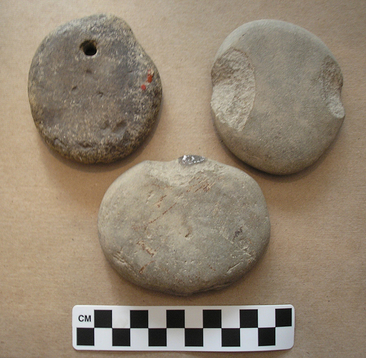
Net sinkers of from the Garney Barr Collection. Mr. Barr spent a lifetime collecting artifacts on his family farm along the Lake Ontario shore. (large view)
In general everyone we interviewed was tremendously helpful and pleasant. The land-owners did not have the multitude of small collections that was expected, but there were a few farmers with very nice collections and a number of home owners with some wonderful finds. Many landowners were also happy to contribute bits of local lore, some easier to substantiate than others. The diving community was also surprisingly open and contributed a number of fish weir sites, in addition to shipwrecks and structures. The greatest single sources of information, however, were the knowledgeable locals. These individuals had the greatest knowledge of unrecorded archaeological sites and pointed out sites and features that we would have missed or had difficulty interpreting during our walk-over surveys.
Much of this success can be credited to the amiable nature of the people of New York; however, we also benefited from credibility provided by media coverage and a local volunteer. Early in the project we were interviewed by the local newspaper and a television station. This exposure went a long ways towards introducing us to the community. Most interviewees were not surprised to see us on their door steps and knowing that we were legitimate made them more comfortable and talkative. Our local volunteer, Terry Baker, was also a tremendous asset in these interviews. Terry is a retired school principal with deep roots in the community. He knew many of the interviewees or could relate to them through a geographical or personal connection. Again, this credibility helped our cause immeasurably.
All of the information gathered through these interviews will be synthesized with the more traditional historical and archival data to supplement what we find during the marine survey. The next journal entry will discuss the results of the remote sensing survey and our diver inspections of various targets.
Please feel free to contact Ben at benford@tamu.edu with any comments, questions, or suggestions during the weeks to come.
Return to Project Journal home page.