

- MUA Home
- All Project Journals
-
- Introduction
- 24 July 2007
- 27 July 2007
- 8 Aug 2007
- 28 Aug 2007
- 17 Sept 2007
- 26 Feb 2008
- 19 Mar 2008
- 27 May 2008
- 5 June 2008
- 23 June 2008
- 25 June 2008
- 12 Aug 2008
- 23 Aug 2009 NEW
- 10 Sept 2009 NEW
-
- About the Author
- Acknowledgments
- Ford Interview
-
- The top banner is a portion of a circa 1772 map of Lake Ontario by Thomas Kitchin. While beautifully engraved, the map, like most of the period, is grossly inaccurate. However, it does offer insight into the place names and significant locations of eighteenth century Lake Ontario. Archives of Ontario C-87-01.
Click here to view map.

The Lake Ontario Maritime Cultural
Landscape Project
5 June 2008
By Ben Ford
Probing for a War of 1812 Gunboat
As some of you may recall from the 26 February 2008 journal entry, there is a possibility that we had located an American gunboat from the War of 1812. The possible wreck site was defined by several magnetic anomalies near where an historic chart indicated the wreck was located. In order to follow up on this possibility we decided to probe the anomaly locations. We hoped that this exercise would give us a better idea of where the gunboat wreck was situated and if it existed at all. Probing had the added benefit of keeping us busy while we waited to hear how long it would take for the magnetometer to be repaired.
The probing process. The things we do in the
name of science.
We constructed a probe by fitting a six-foot long piece of all-thread into an Oakfield hand corer. The folks at Oakfield had the foresight to make their corer just large enough that a ½-inch nut fits inside but can not turn. As a result, we were able to lock the all-thread into the corer making a six-foot probe with a convenient T-handle. We could even put a little slack between the all-thread and the corer so that we had more momentum on each down push. Based on the locations of the magnetic anomalies, I planned a 5-meter probing grid using Hypack, the same program that we use to guide our survey lines. I decided on a 5-meter grid because the gunboat may have been only 18 feet wide and a wider grid could miss it entirely. With a probe, a plan, and a rowboat borrowed from Dennis Whelpley, a local property owner, we were ready to look for the gunboat.

The probe.
Initially, I wanted to probe the entire area encompassing the magnetic anomalies as well as the location indicated on the historic chart. However, after four hours and 100 probes, the prospect of nearly 600 more probes did not sound as appealing. The next day out we decided to focus our attention on the locations immediately around the magnetic anomalies and fell into a workable pattern with Jessi and Terry in the boat navigating and keeping records, Brad maneuvering the boat from the water, and myself driving the probes. Each of these tasks had its own challenges, ranging from trying to keep track of closely spaced probe locations in a pitching boat to repeatedly pounding your face into frigid water, but with this division of labor we were able to put in 279 probes to a minimum depth of 5 feet below the sediment in water ranging from 2 to 4 feet deep.

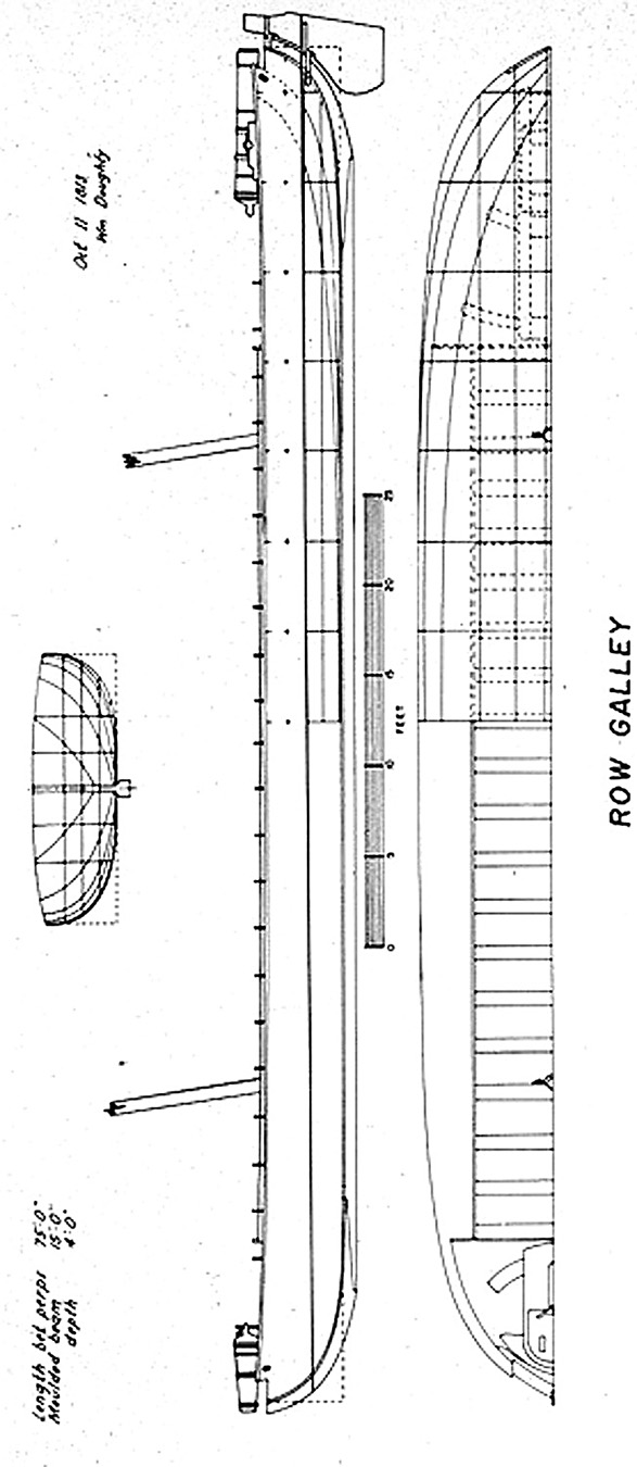
What the gunboat may have looked like. An American gunboat from the War of 1812 as illustrated in Howard Chapelles The History of the American Sailing Navy and based on the Doughty plan. (large view)
Most of the targets were negative, meaning I was able to push the full length of the probe into the sediment without encountering an obstruction. Some of the probe locations were positive where the probe hit a definite obstruction. There was also the third category of possible. Possible targets were those where I could force the probe down, but only with great difficulty. These locations may have been simply dense patches of sand or they may have been very soft wood. We recorded the depth of the obstruction for both positive and possible probes.
The preliminary results of this exercise are included here for you to review. I think there might be something in the group of probes situated near the lower center of the graphic. Admittedly, the image is a bit of a Rorschach test where you can see whatever your imagination fancies (and, as always, feel free to contact me with alternative interpretations). However, in the lower center group the positive and possible probes seem to form both a north-south and east-west alignment that measure approximately 75 feet in length (the likely length of the gunboat). These hits may be the gunboat, but they may also be a collection of tree trunks or particularly hard sand. The only ways to follow up on this location is to partially excavate the area or conduct a close-interval sub-bottom profiler survey of the area. Both of these options will require additional time and funds so the gunboat will remain a mystery for a bit longer, but we are getting closer.

Results of the probe survey.
Please feel free to contact Ben at ben.ford@iup.edu with any comments, questions, or suggestions during the weeks to come.
Return to Project Journal home page.