

- MUA Home
- All Project Journals
-
- Introduction
- 24 July 2007
- 27 July 2007
- 8 Aug 2007
- 28 Aug 2007
- 17 Sept 2007
- 26 Feb 2008
- 19 Mar 2008
- 27 May 2008
- 5 June 2008
- 23 June 2008
- 25 June 2008
- 12 Aug 2008
- 23 Aug 2009 NEW
- 10 Sept 2009 NEW
-
- About the Author
- Acknowledgments
- Ford Interview
-
- The top banner is a portion of a circa 1772 map of Lake Ontario by Thomas Kitchin. While beautifully engraved, the map, like most of the period, is grossly inaccurate. However, it does offer insight into the place names and significant locations of eighteenth century Lake Ontario. Archives of Ontario C-87-01.
Click here to view map.

The Lake Ontario Maritime Cultural
Landscape Project
25 June 2008
By Ben Ford
Carleton Island and Barrett Bay
After four difficult weeks with uncooperative weather and malfunctioning equipment we finally finished the survey at Carleton Island and moved on to Barrett Bay on Wolfe Island. Protected from the prevailing winds and with a more convenient dock, the Barrett Bay survey has progressed much more quickly. In this journal entry I’ll summarize the results from both of these areas.
.")
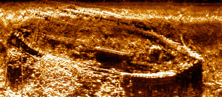
Side scan record of the Barrett Bay coal barge (Keyes Wreck). (Large View)
The majority of our findings at Carleton Island pertained to the development of the island as a vacation getaway for wealthy Americans during the late 19th century. The area is full of deteriorating docks and boat house foundations, as well as scattered architectural elements such as a copper alloy finial ball and a section of decorative railing. There was also plenty of trash, likely dumped on the ice to “disappear” in the spring, including an old push lawnmower and an early tub-shaped washing machine. We also recorded some slightly earlier sites, such as stone filled cribs associated with a ferry dock that once served both the vacationing and residents of the western portion of the island and the farmers who worked the eastern uplands. Through the help of property owners we have also recorded artifacts associated with the Revolutionary War and the agricultural development of the island shortly after the war of 1812. Walking the shore also yielded evidence of the Native American presence in the form of a stone flake, the byproduct of tool production.
Based on these findings and the recorded history of the island, Carleton Island nicely encapsulates many of the shoreline transitions of the region. The island was initially used for resource procurement and as a stopping point for Native Americans crossing the St. Lawrence River. It was then developed as a military instillation during the American Revolution, but was largely abandoned when the British moved their naval base to Kingston. The island was next developed by farmers expanding from the “King’s Gardens” used to feed the garrison stationed on the island. After nearly 50 years of agricultural production, the island became the scene of early tourism in the St. Lawrence region with an American industrial magnate building his ‘villa’ on the eastern portion of the island. Meanwhile the uplands of the remainder of the island continued to be used for agricultural production, eventually becoming the pasture for approximately 500 cattle. The initial development of Carleton Island for vacation homes ended with the Great Depression, but there has been a resurgence of recreational development during the past decade as an increasing number of summer homes are built. This development, however, is tempered by a preservation ethic through the efforts of the Thousand Islands Land Trust. Clearly, this study area has much to offer our investigation of how human use of the shore changed with time.
The Wolfe Island survey area is centered on Barrett Bay, immediately east of the island’s main settlement, Marysville. This area was particularly attractive because it forms the mouth of the Wolfe Island Canal. Our work in this area has identified a coal barge (already known to local residents but an interesting wreck nonetheless), an abandoned vehicle that was converted to a duck blind, and several old docks. The lands surrounding Barrett Bay are the only ones in any of the survey areas that are still in active agricultural use. This condition gave us the opportunity to walk the fields and look for artifacts. This exercise identified a mid-19th century debris scatter that included an intact clay pipe bowl with a raised ship design on one side and a similar anchor on the other. This find is the current front-runner for mascot artifact of the project. We also found a possible biface and a projectile point that appears to date to the Middle Archaic Period (though I need to verify this with someone more knowledgeable about lithics than myself). All told Barrett Bay was a productive survey area.
Together Wolfe Island and Carleton Island form an interesting link between the Canadian and US portions of the survey. There was once a ferry that left Cape Vincent in New York, touched on Carleton Island, and then proceeded on to Wolfe Island and eventually Kingston, Ontario. The canal on Wolfe Island was initially built as part of a plan to connect New York City and Kingston by rail, opening new markets to Ontario produce. Unfortunately, the railroads were late in coming to Kingston and the plan fell through. However, for many years the canal provided easy access from the US to Canada and strengthened the ties of family and commerce that link Wolfe Island to northern New York.
This week we'll finish at Barrett Bay and move out of our lovely 19th century farm house on Wolfe Island for a rental property near Kingston. From there we will complete the final survey in Parrotts Bay.
More to come.
Please feel free to contact Ben at ben.ford@iup.edu with any comments, questions, or suggestions during the weeks to come.
Return to Project Journal home page.