


- Recent Guest Blogs
- Timothy G. Lynch
- Amanda Evans
- Dave Howe
- Archive of Past Bloggers
- Anthology PDF
- Maritime Art Gallery
- Educational Resources
- Teaching Kit
- Worldwide Site Map
- Links
- U of Rhode Island
- The MUA is a non profit 501c3 organization. Please consider supporting our mission of public outreach with a donation.
In 1998 Western Michigan University archaeologists entered into a partnership with STF, the City of Niles, and the Fort St. Joseph Museum to conduct an archaeological survey in search of material remains of the fort. In the fall of 1998, we examined a 15-acre parcel of city-owned land that corresponded with the placement of a fort symbol on a ca. 1900 anonymous map (Nassaney 1999). We used a variety of survey techniques to identify and recover an assemblage of 18th-century artifacts including gunflints, gun parts, brass kettle fragments, lead waste, glass trade beads, and European ceramics. We also identified architectural remains including hand-wrought nails and building stones (Nassaney et al. 2003). Finally, we collected a large assemblage of well-preserved wild animal food remains, as well as several pig teeth.

A photo taken in March 2011 shows the extent of the annual inundation.
These materials were recovered from a landform that is adjacent to the flood pool created by the damming of the St. Joseph River in the late 19th century. The original dam and subsequent 20th-century additions have raised the water level approximately 10-12 feet (3-4 m) above the elevation of the river as it was in the 18th century. As a result, the water table is about 20 cm below the ground surface under dry site conditions, making it difficult at best to observe features or stratigraphic relationships in the ground. During wet seasons the site is completely inundated. It became obvious that innovative field techniques would be needed if we were to successfully evaluate and document the integrity of the deposits.
Archaeologists from Western Michigan University returned to the site in May 2002 to conduct a more intensive site evaluation that would allow us to demonstrate conclusively that the previously identified materials were associated with Fort St. Joseph. Our goals were to determine the vertical stratigraphic relationships of the cultural deposits, recover a larger sample of artifacts and ecofacts from undisturbed contexts, and establish site integrity by identifying subsurface features including in situ architectural remains should they exist. We began by draining the site, followed by a geophysical survey and the excavation of 20 square meters of site area. Subsequent work has led to the excavation of over 80 square meters of the site.

Diesel pump used to dewater Fort St. Joseph.
To lower the ground water table and create dry site conditions for successive field seasons we regularly employ a drainage system (Nassaney et al. 2002-2004). The dewatering system up until 2009 consisted of 60-70 well points, 14 feet in length, which were placed approximately one meter apart. Each of these pipes was attached via a small length of clear hose to a header pipe that was eight inches in diameter. The PVC piping for this system was totally portable and removed at the end of each year. The vacuum pressure for the system was provided by one large diesel powered pump, placed at the end of the access road on the westernmost edge of the landfill along the riverbank. The diesel pump was self priming and could remove 800 gallons of water per minute from the site sediments. The pump needed only to be started each morning, literally a turn-key operation.
In addition we used geophysics to detect subsurface anomalies across a 480 square meter grid within the drained area and then expanded it west and north onto the frozen river. Of the methods employed, magnetometry was the most effective as it detected several culturally significant anomalies (Nassaney et al. 2002-2004). The geophysical survey indicates that some site features exist beneath the river, deposits may extend beneath the landfill, and the site covers an area of at least 1500 square meters. We used the results of the geophysics and our 1998 subsurface testing to guide excavations.
Excavations have demonstrated that Fort St. Joseph contains undisturbed deposits that can provide information about life on the 18th-century frontier. A consistent stratigraphic profile was noted over much of the site (Nassaney et al. 2003). The upper 25-30 cm consists of highly organic alluvial sediments deposited since the late 1930s when the height of the dam was increased. This stratum is underlain by a gray silty loam to a maximum depth of 60 cm below surface. This horizon represents the buried 19th-early 20th century plow zone and contains high densities of 18th-century artifacts and well-preserved animal bones. Evidence of undisturbed architectural remains and archaeological features associated with 18th-century objects occurs immediately below the plow zone in a majority of our excavation units. A representative sample of small-scale archaeological materials (e.g., glass beads, plant and animal remains) was recovered using flotation and a system of fine mesh (1/8” and 1/16”) water screening of systematically collected soil samples. The soil conditions do not pose stabilization problems for artifacts encountered in the field, thus eliminating the need to have an archaeological field conservator on site during excavation.

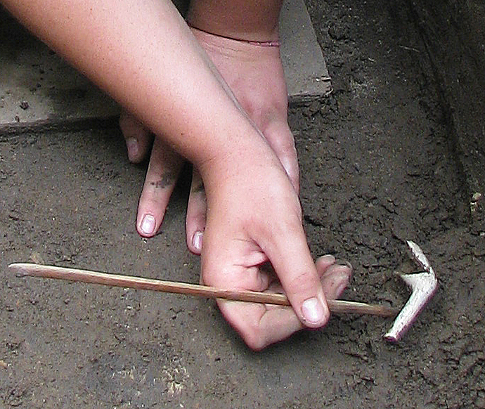
A field school student carefully excavates a white clay pipe (Large View ).
Several large stone fireplaces associated with 18th-century artifacts have been located. These include objects that relate to personal and household activities. Imported ceramics of faience, creamware, pearlware, and red stoneware may indicate the persistence of European dining practices. We also recovered several Micmac-style stone pipe bowls, red pipestone bowl fragments, bone gaming pieces (platter dice), and religious paraphernalia. Together with the European ceramics, these objects suggest the eclectic nature of this household assemblage perhaps indicative of creolization. We propose to conduct further work to examine areas in proximity to fireplaces to determine associated building styles and collect a larger sample of related artifacts. Variation in form or contents may relate to functional and/or chronological differences and have implications for the social identities of their makers and users.
Another, much larger, pit (Feature 7) that was detected as a diffuse high magnetic circular anomaly approximately 3 m in diameter proved to be more than 1.4 m deep and filled with debris such as large domesticated animal bones, a bear canine, hand-wrought nails, charcoal, and ash. It also contained many fist-sized pieces of baked clay or daub with log and straw impressions, some of which exhibit white washed surfaces indicative of chinking (bousillage) from poteaux en terre (post in ground) or poteaux sur sole (post on sill) structures. The use of vertical timbers chinked with bousillage is a well-documented construction method for 18th-century French houses in North America (see Gums 2002; Peterson 2001:41-44; Thurman 1984:2; Waselkov 2002b:9). Subsequent work in 2009 indicated the substantial size of this feature, suggesting that it may be a well or more likely a cellar. Further excavation is needed to determine this feature’s overall shape and to recover a larger sample of its contents in order to infer its original function.
In addition to these artifacts, many of the features were associated with significant quantities of well-preserved animal bone. Analysis of the faunal assemblage indicates a high frequency of wild animal species, dominated by deer (Becker 2004). Cattle, swine, and chicken, while present, represent only a small proportion of the identified remains. Many specimens display cut marks and chopped margins; excellent preservation of the bones permits us to see butchering marks that range from small, faint marks and striations to larger, more obvious chopping marks that probably resulted from the use of a large heavy blade. Many of the deer bones are splintered, perhaps as a result of fracturing in preparation for boiling to extract the grease. This was likely an opportunistic economic activity that the residents undertook for household consumption or to produce a commodity for exchange.
These preliminary results conclusively demonstrate the presence of intact structural remains, in-ground facilities, and undisturbed artifact deposits associated with abundant, well-preserved food remains at Fort St. Joseph on a landform adjacent to the St. Joseph River in Niles. Although the geophysical survey suggests that the site of Fort St. Joseph extends beneath the landfill, the archaeological evidence clearly affirms the site’s considerable potential to make significant contributions to our understanding of ethnogenesis and the formation of new social identities among the residents of Fort St. Joseph.

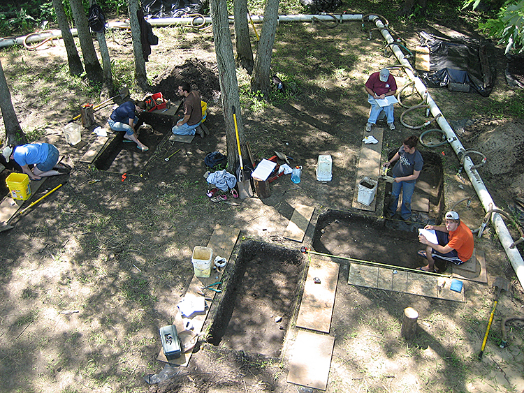
The field school students at work. Note the old dewatering system piping surrounding the excavation units (Large View ).
Archaeological field schools have been conducted in Nile Michigan at the site of Fort St. Joseph in 2002, 2004, and in 2006 through 2010. After many years of excavation conducted with the help of a diesel-powered pump, a new quieter and more efficient electric dewatering system has been employed since 2009. The new system relies on four electric pumps running in tandem to remove ground water from the site of Fort St Joseph. Our most recent field season, 2010—the 35th annual archaeological field school hosted by Western Michigan University—continued work on the fort site.
Again in 2010 electric pumps were installed at the site to assist in lowering the ground water table at the site. They were fitted to the well point system that was left in place from the previous field season. The system sustained no damage and we were able to successfully draw down the water table using a cleaner, quieter, and more cost effective system than the diesel pump provided. Excavations resumed in areas where we had previously identified architectural features and sub-surface anomalies in the hopes of exposing structural remains and associated activities. As in previous years the underlying plow zone soil was dug in 5-cm levels and all soil was collected by trowel and wet-screened using 1/8” mesh to recover a representative sample of artifacts, seeds, and animal remains.

One of the electric pumps utilized in 2009 and 2010.
In 2010, six 1x2 meter excavation units were dug adjacent to previously identified features. Three new features were identified during the six weeks of excavation at the site, including a stone foundation and upright wooden posts shedding light on how structures at the fort were possibly constructed. A number of notable artifacts were found as well including a metal cache containing several iron hand-wrought nails and screws, a butt plate, trigger guard, an iron ax head, and several other unidentified pieces of iron hardware. This hoard may be associated with the gunsmith’s cache located less than 10 meters to the northeast or may be evidence of a specific accumulation of material waiting to be fixed or refurbished. This area has also yielded a plethora of trade beads, unfired musket-balls, lead shot, and other marketable trade items suggesting the presence of a storeroom nearby.
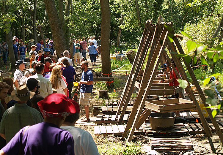
The field program also employs a stellar public archaeology program which revolves around community service learning and education and outreach events. All the events help reinforce the project’s commitment to community engagement in and around southwest Michigan. In 2010 three weeklong summer camps were run in association with the local Fort St. Joseph Museum. A total of 26 individuals, including adults and middle school students, learned how to excavate properly, take field notes, and identify artifacts in addition to gaining an appreciation for the importance of archaeological materials in the interpretation and reconstruction of history and culture. This past year, the project also hosted a four-part lecture series in which speakers gave presentations pertaining to the women of New France. This was also the focus of the open-house event, which culminates the field season. During the open house, community members had the opportunity to attend lectures, witness and participate in demonstrations by historical reenactors, peruse an outdoor museum featuring artifact displays highlighting notable finds from the field season, and interact with the field school students while viewing ongoing excavation. Since 2006, nearly 10,000 visitors have attended the archaeological open house. Events from the summer camps to the open house all assist the project in better serving the needs and desires of the local community while helping bring the history and culture of Fort St. Joseph to life. The open house theme in 2011 will be Fort St. Joseph’s role in the fur trade to be held August 13-14.

Some 1,500 visitors attended the 2009 Open House event (Large View ).
To learn more about Fort St. Joseph and how you can get involved visit our website: http://www.wmich.edu/fortstjoseph/
Also see us on facebook:
http://www.facebook.com/pages/Fort-St-Joseph/130145060360815#!/pages/The-Fort-St-Joseph-Archaeological-Project/265011456817
References
Return to In The Field home page.
Comments, suggestions, or questions can be directed to research@themua.org